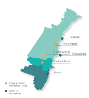
The Illawarra is home to about 300,000 people living in the Wollongong, Shellharbour and Kiama local government areas. The region occupies a narrow strip, bounded by the Illawarra escarpment to the west and the coastline between Garie Beach in the north and Gerroa in the south. Proximity to the coast and the Illawarra's terrain significantly influence local weather patterns and consequently air quality in the region.
Air Quality Trends in the Illawarra

Air Quality Trends in the Illawarra describes how air quality has changed in the Illawarra over the past two decades. It draws on data from Office of Environment and Heritage's air quality monitoring network, emission inventories, air quality modelling and particle speciation studies. It also describes the local airshed and identifies areas of future research to expand our understanding of air pollution and its impacts.
This report will inform a range of measures to continue to improve air quality in the Illawarra.
- Air Quality Trends in the Illawarra (PDF 4.6MB)
- Infographic (PDF 6MB)
- Illawarra Air Quality Summary (PDF 393KB)
- Summary - Macedonian (PDF 274KB)
- Summary - Italian (PDF 247KB)
- Summary - Arabic (PDF 431KB)
Air quality in the Illawarra has been generally improving over time. Carbon monoxide, nitrogen dioxide, sulfur dioxide and lead levels have decreased since the 1990s and are all consistently below national standards. However particle (PM10 and PM2.5) and ozone levels can exceed national standards from time-to-time, posing health risks.

